
History
Natural Disasters in the Maldives
Disasters and Extreme Events
The geography, natural setting, small size of the coral islands of the Maldives makes the entire population and build their infrastructures to be close proximity to the shorelines. Any impacts due to climate change, extreme events and natural disasters makes us as one of the most vulnerable to these effects. Our economic activities too are based on marine and coastal resources, hence any impact on these both makes our economy also as one of the most vulnerable.
Maldives have experienced number of extreme events, including fury of cyclones, localized or freak storms, flooding or inundation of parts of islands due to strong wind and heavy rainfall according to Manik (1990). Some of these events have lead to relocate entire populations of some of islands and coupled to damage to livelihood and economy.
The close proximity of the entire population and the infrastructure of the Maldives to the coast subjects the entire nation to impacts from climate change and other natural disasters. In recent times natural disasters and extreme whether events had a strong impact on the economy and the Maldivian society.
One of the significant events in recent times are; strong tidal wave which occurred in April 1987, storm surges in May 1991 among others.
Both physical and economic vulnerability of Maldives have been identified as one of the highest among the world (Pernetta, 1991) due to extreme weather events and natural disasters. The Indian Ocean Tsunami of December 2004, provided a snap shot of long term slow onset events due to impacts of climate change and sea level rise and vulnerability of Maldives to natural disasters. It was another wakeup call to be more prepared in the event of extreme events and natural disaster. Fragile ecological profile, low elevation, combined with its economic dependence on limited sectors (tourism and fisheries) makes Maldives highly vulnerable to natural disasters.
Disaster Risk Profile of Maldives by UNDP (2006a) identifies following natural disasters as risks to Maldives
Contents
- Geography
- Earthquakes and Tsunami events
- Cyclones and Thunderstorms
- Flooding due to rain
- Drought - History
- Storm Surges
- Strong Winds and Tornados
Geography
The Maldives comprises 1192 islands located along a North-South transect at 73 E longitude that spans 0.5S to 7 N. 199 islands are inhabited. The islands are small with only 33 exceeding a square kilometer in area and 3 exceeding 4 square kilometers. Other islands along this undersea mountain ridge include the Lakshadweep islands of India to the North and the Chagos Islands to the South. The analysis of rainfall along this transect is important as it provides insight into the Asian monsoon and the climate of the tropical Indian Ocean that complement studies over India and Sri Lanka. Rainfall in Maldives is year-round and its study complements that of the Indian summer monsoon rainfall that extends from June to September. The climate is important to the Maldives, a small island developing state, as it directly affects the principal sectors of livelihood, food supply such as tourism, fisheries, agriculture and water resources. The population of 330,000 is also vulnerable to hydro-meteorological disasters and weather related diseases such as dengue - the vulnerability is accentuated because of difficulties in transport and access from remote islands to more populated islands.
Earthquakes and Tsunami events
Earthquake events have been documented in the archives of Maldives history, where as there is very little recorded evidence of tsunami events. Historical records shows that between 1729 and 1815 Maldives had experienced earthquakes. Although magnitude and exact locations of these historical earthquakes around the Maldives is unavailable, descriptions of the events.

Figure 1: Historic earthquake events (adapted from UNDP, 2006)
In recent times, three major earthquakes of magnitude 7.0 or greater had struck the Maldives region in 1944, 1983 and 2003. Earthquakes are usually felt as tremors without notable damages. However, in 2003 earthquake measuring 7.6 occurring in Carlsberg Coast Zone in the north and Carlsberg Transform Fault Zone in the south since 1816, historical records do not indicate Maldives has been affected by any of these tsunamis. The only record of damages caused by a tsunami in the Maldives is 26th December 2004 Indian Ocean tsunami. This was one of the most apocalyptical natural disasters experienced in the Maldivian history. Wave heights of about 2.5m were recorded in Hanimaadhoo and a wave height of 2.1m was observed in the Malé City.
It was reported that 26 people missing, 82 dead and more than 2000 homes destroyed with extensive damage to the property and infrastructure (UNDP, 2006). Financial losses were 62% of the GDP which was approximately USD 470 million (ADRC, 2005). The economic repercussions of the tsunami were felt in the following year with a budget deficit of USD 80 million to carry out immediate relief and reconstruction work and drop in the tourism revenues in 2005.
As a result of the tsunami, with the assistance from the international community, the government developed the National Recovery and Reconstruction Plan to address the disaster risk in the post tsunami infrastructure redevelopment in the Maldives. A Safer Island Development Programme was launched to bring comfort to the population which was severely shaken by the major earthquakes of magnitude 7.0 or greater had struck the Maldives region in 1944, 1983 and 2003 (Figure 4–1). Earthquakes are usually felt as tsunami disaster event. The Safer Island Development Programme presents a holistic development agenda of the country bringing together many sectoral developmental initiatives such as the infrastructure and population consolidation (Jameel, 2007).
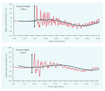
Figure 2: Tsunami on 26th December 2014 where the upper panel is water levels at Hanimaadhoo and lower is for Malé (data from University of Hawaii Sea-level Centre)
Source : http://www.environment.gov.mv/v2/wp-content/files/publications/20161030-pub-second-national-comm-oct2016.pdf
The key focus of disaster management is to reduce the vulnerability of the communities exposed to hazards and risks and to help them to enhance their resilience. The Hyogo Framework for Action 2005-2015: The Hyogo Declaration(2005) called upon countries to develop strategies to reduce their vulnerabilities by means of integrated environmental and natural resource management approaches that incorporate disaster risk reduction, including structural and nonstructural measures and enhance the resilience of the community at the grass root level. In addition, the government undertook several legislative measures and development of projects to address the disaster risk management. This was given a high priority in several key government policy documents and development plans such as the Seventh National Development Plan (2007), the Third National Environmental Action Plan (2009) and the National Sustainable Development Strategy (2009). The Disaster Management Act was enacted in 2015 to strengthen the disaster risk management framework and promote collaboration among various stakeholders so that disaster response measures could be undertaken in a coherent manner.
Cyclones and Thunderstorms
Available historical records indicate that Maldives has experienced climate/weather related extreme events such as cyclones and storms, floods, droughts, high waves and tornadoes. Compared to the other countries in the region, the islands of Maldives are less prone to cyclones. Occurrences of cyclonic disturbances are observed during the south-west monsoon season from October to January. An analysis of the cyclone tracks shows that 11 cyclones crossed Maldives during 1877 to 2004 (UNDP, 2006). Figure 3 shows that northern part of Maldives is more susceptible to cyclones than the south
The most recent impacts were by cyclones “Nilam” and “Madi” in 2012 and 2013 respectively. Extensive damage due to high wind and flooding due to torrential rain was experienced in several parts of the country during these events.
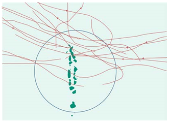
Figure 3: Cyclone tracks which affected the Maldives between 1877 and 2004 (adapted from UNDP, 2006)
Source : http://www.environment.gov.mv/v2/wp-content/files/publications/20161030-pub-second-national-comm-oct2016.pdf
Flooding due to rain
Although floods due to rain are the most frequent natural events in the Maldives, no criteria exist for the case of the Maldives for declaring flood disasters. Furthermore, no proper mechanism exists for collecting or recording data on flood events and hence it is difficult to determine frequency of floods and their trends for the Maldives. However, studies such as Parthasarathy et al4 (1994) and Zahid (2011) have estimated flood and drought years based on rainfall data. Figure 4 shows flood years together with drought years for the three regions of Maldives.
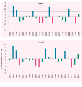
Figure 4: Flood and drought years for: (a) northern, (b) central and (c) southern Maldives based on Maldives monsoon rainfall. Cross bars indicate the flood years, dotted bars indicate the drought years. Solid line is the sum of mean and standard deviation and dotted line is the difference between mean and standard deviation.
Source : http://www.environment.gov.mv/v2/wp-content/files/publications/20161030-pub-second-national-comm-oct2016.pdf
It shows that the north and central regions are equally prone to extreme flooding, while the southern region Water Solutions is less prone to extreme flooding due to rain. It should be noted that this method identifies the likelihood of flooding and actual flood events experienced can be very different.
Figure 5 shows an analysis of actual reported cases of flooding due to rain obtained from NDMC, MMS, and other reporting authorities for the period 19902013. The highest number of flood events was recorded in 2007 while the highest number of flooded islands was reported in 2012. There are some discrepancies in similar results from other studies. MEEW (2006) reports that 71 inhabited islands flooded in 2004 alone due to severe weather events. These inconsistencies highlight the need of a proper mechanism for reporting and archiving flood events.
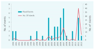
Figure 5: Flood events due to rain and number of islands impacted by floods
Source : http://www.environment.gov.mv/v2/wp-content/files/publications/20161030-pub-second-national-comm-oct2016.pdf
Parthasarathy et al (1994) defines excess (wet) or flood year as when monsoon rainfall (JJAS total rainfall) is Ri≥R +̅ S and a deficient (dry) or drought year as when monsoon rainfall (JJAS total rainfall) is Ri ≤R ̅-S , where Ri is the monsoon rainfall of the ith year,R ̅ is the mean and S is the standard deviation of the data series
.png)
Figure 6: Observed and predicted (for years 2025, 2050, 2075 and 2100) return periods for: (a) northern, (b) central and (c) southern Maldives regions based on daily rainfall for the periods 1992-2009 (northern), 1975-2009 central) and 1980-2009 (southern); (adapted from Zahid, 2011).
Source : http://www.environment.gov.mv/v2/wp-content/files/publications/20161030-pub-second-national-comm-oct2016.pdf
Based on the extreme rainfall events, a rainfall of more than 50 mm in 24 hour is decided as an extreme rainfall event in the Maldives. The flood impacts associated with a particular rainfall threshold may depend on geography (whether the island has low lying and flood prone areas), shape, soil type and the depth of the water lens of that particular island. As flash flood impacts associated with particular rainfall threshold values can have different impacts on different islands, rainfall threshold range can be used identifying flood related impacts as in Annex F. An analysis of the return periods of the extreme rainfall events (Figure 4–6) indicate that the extreme flooding events are likely to become more frequent in the future with changing climate. A daily rainfall of 150 mm for the northern region is a 300 year event which might become a 23 year event by the end of the century. Similarly a 190 mm rainfall for the central region, currently 387 year event, could become a 62 year by the end of the century.
An analysis of the return periods of the extreme rainfall events (Figure 4–6) indicate that the extreme flooding events are likely to become more frequent in the future with changing climate. A daily rainfall of 150 mm for the northern region is a 300 year event which might become a 23 year event by the end of the century. Similarly a 190 mm rainfall for the central region, currently 387 year event, could become a 62 year by the end of the century.
Drought - History
Similar to flood events, no proper mechanism exists for collecting or recording data on drought events in the Maldives, and hence data on drought or prolonged dry periods are lacking. Furthermore, no criteria exist for declaring drought events for the Maldives. As shown in Figure 4–4 the northern and central regions show an equal number of deficit rainfall years (4 deficit rainfall years), indicating that these two regions are equally prone to drought events. In order to determine prolonged dry periods, greatest number of consecutive dry days (CDD) (Figure 7) between December-April (longest period of consecutive days with no or less than 1 mm precipitation) was identified for each year for north, central and southern regions for the period 1992-2013. Northern and Southern regions of Maldives show both decreasing trend of CDD, while the central region shows slight increasing trend (very little change in the maximum number of consecutive dry days) for the same period. On average, northern and central regions experience approximately a month long consecutive dry period while it is half a month in the southern regions.
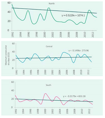
Figure 7: Maximum consecutive dry days during the months of December to April.
Source : http://www.environment.gov.mv/v2/wp-content/files/publications/20161030-pub-second-national-comm-oct2016.pdf
Storm Surges
Swell waves that generate far from Maldives (in the Indian Ocean, west of Australia, off the coast of Madagascar) are known to cause flooding in the Maldives islands (NDMC, 2007), causing damages to properties, household goods, saltwater intrusion to groundwater aquifer and erosion. Furthermore, tidal waves (caused by the forces of the moon, sun, and planets upon the tides, as well as the wind as it moves over the water) can flood the islands of Maldives, particularly when the storm tide coincides with the normal high tides causing severe flooding in coastal areas. The southwest monsoon from May-November are known to generate waves of high intensity.
In the past Maldives have experienced flooding associated with high waves. One of the most reported cases of wave events and number of flooded islands due to waves from 1991-2013. On average 2-3 events of flooding due to storm surges are experienced every year.
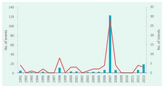
Figure 8: Reported cases due to strong wind
Source : http://www.environment.gov.mv/v2/wp-content/files/publications/20161030-pub-second-national-comm-oct2016.pdf
Maldives. Figure 9 shows the reported cases of damage due to strong wind. Analysis of return periods of wind indicates that gust wind speed of 50 miles per hour is almost an every year
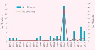
Figure 9: Reported cases of tidal waves and number of islands flooded due to waves
Source : http://www.environment.gov.mv/v2/wp-content/files/publications/20161030-pub-second-national-comm-oct2016.pdf
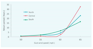
Figure 10: Return periods for gust wind speeds
Source : http://www.environment.gov.mv/v2/wp-content/files/publications/20161030-pub-second-national-comm-oct2016.pdf
Strong Winds and Tornados
Maldives experience strong winds during monsoon season, from May to November. Strong winds can damage vegetation, houses, communication systems, roads and causeways. Sustained strong winds can lead to rough seas thus disrupting sea transportation, in which most of the Maldivians depend on for commuting between islands and for transporting goods and food items. Rough seas associated with strong winds have caused ship wrecks and boat accidents, causing damages to boats and sometimes threatening lives. Strong winds have disrupted air transportation services in the Tornados are not very common in Maldives. However, small in size “weak” tornados have been reported. Figure 11 shows the number of reported cases due to damage from tornados. It indicates that number of incidences has increased in recent times.
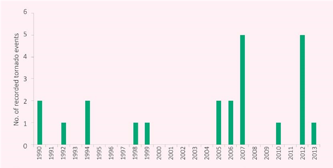
Figure 11: Reported cases of tornado events
Source : http://www.environment.gov.mv/v2/wp-content/files/publications/20161030-pub-second-national-comm-oct2016.pdf