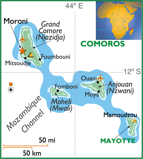
Jazidja is the largest island, sixty-seven kilometers long and twenty-seven kilometers wide, with a total area of 1,146 square kilometers. The most recently formed of the four islands in the archipelago, it is also of volcanic origin. Two volcanoes form the island's most prominent topographic features: La Grille in the north, with an elevation of 1,000 meters, is extinct and largely eroded; Kartala in the south, rising to a height of 2,361 meters, last erupted in 1977. A plateau averaging 600 to 700 meters high connects the two mountains. Because Njazidja is geologically a relatively new island, its soil is thin and rocky and cannot hold water. As a result, water from the island's heavy rainfall must be stored in catchment tanks. There are no coral reefs along the coast, and the island lacks a good harbor for ships. One of the largest remnants of Comoros' once-extensive rain forests is on the slopes of Kartala. The national capital has been at Moroni since 1962.
Nzwani, triangular shaped and forty kilometers from apex to base, has an area of 424 square kilometers. Three mountain chains--Sima, Nioumakele, and Jimilime--emanate from a central peak, Mtingui (1,575 meters), giving the island its distinctive shape. Older than Njazidja, Nzwani has deeper soil cover, but overcultivation has caused serious erosion. A coral reef lies close to shore; the island's capital of Mutsamudu is also its main port.
Mwali is thirty kilometers long and twelve kilometers wide, with an area of 290 square kilometers. It is the smallest of the four islands and has a central mountain chain reaching 860 meters at its highest. Like Njazidja, it retains stands of rain forest. Mwali's capital is Fomboni.
Mahoré, geologically the oldest of the four islands, is thirty-nine kilometers long and twenty-two kilometers wide, totaling 375 square kilometers, and its highest points are between 500 and 600 meters above sea level. Because of greater weathering of the volcanic rock, the soil is relatively rich in some areas. A well-developed coral reef that encircles much of the island ensures protection for ships and a habitat for fish. Dzaoudzi, capital of Comoros until 1962 and now Mahoré's administrative center, is situated on a rocky outcropping off the east shore of the main island. Dzaoudzi is linked by a causeway to le Pamanzi, which at ten kilometers in area is the largest of several islets adjacent to Mahoré. Islets are also scattered in the coastal waters of Njazidja, Nzwani, and Mwali.
Comoran waters are the habitat of the coelacanth, a rare fish with limblike fins and a cartilaginous skeleton, the fossil remains of which date as far back as 400 million years and which was once thought to have become extinct about 70 million years ago. A live specimen was caught in 1938 off southern Africa; other coelacanths have since been found in the vicinity of the Comoros Islands.
Compiled from US Country Studies of Indian Ocean Islands.