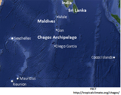
Satellite Images of the Central Equatorial Indian Ocean Region, inset bottom: The Chagos Archipelago, inset top-right: Diego Garcia Atoll, from Google Earth.
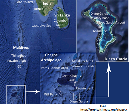
Satellite Images of the Central Equatorial Indian Ocean Region, inset bottom: The Chagos Archipelago, inset top-right: Diego Garcia Atoll, from Google Earth.
|
The Chagos Archipelago is a group of 55 isolated low-lying coral islands in the central Indian Ocean which covers an area of 64 square kilometers of land located between Longitude 71–73°E and Latitude 4.5–7.5°S. The islands are spread over a total area of about 50,000 square kilometers in the center of the Indian Ocean, south of India, about one-half the way from Africa to Indonesia. These islands are supported by the submerged Chagos banks at the southern end of a linear array of islands, and is separated from the Maldives and Laccadives plateau by a 500 km wide and 2200-3300 m deep channel. Chagos Archipelago also consists of five atolls, which are known as Blenheim Reef, Egmont Reef, Diego Garcia, Salomon Islands and Peros Banhos. There are also a number of small islets in Chagos Archipelago such as Ile Aigle, Ile Pierre, Ile de Coin, Ile Sude-Est, Ile de Coin and Ile Boddam. Terrain of these islands are flat and low with most areas not exceeding two meters in elevation. |
|
The largest island of Chagos Archipelago is known as Diego Garcia. Diego Garcia is a horse-shoe shaped coral atoll of 32 km2 land area that lies 55 km south of the Great Chagos Bank. It is the largest and southernmost island, which occupies strategic location in central Indian Ocean. The highest point in Diego Garcia is about 15 m, and the average elevation is 1.2 m, with a perimeter of 64 km and land width ranging from a few hundred metres to 2.4 km, which represents over half the land area of the 55 archipelago islands.
The lagoon of Diego Garcia is large, shallow, and almost completely enclosed by land. Approximately 70% of the atoll area is comprised of the extensive lagoon (11 km2), which is enclosed by one of the most continuous land rims of all coral atolls. The lagoon consists of three main basins: a large northern basin with its floor at 25-30 m depth; a central basin with its floor at 16-.20 m depth; and a southern basin with more intricate topography, isolated by a ridge with depths of only 2-4 m extending entirely across the lagoon. The rim varies in width, height and surface features from place to place, and some sectors are clearly older and more stable than others. The highest point of 15m elevation is an unnamed location on Diego Garcia. The island is currently a site of joint US-UK military facility. (Stoddart, D.R., 1971)
History of Chagos
There is evidence for human habitation in Chagos as in other Indian Ocean Island lasting millennia. In the colonial period, Chagos was settled in the 16th century by the Dutch, who brought slaves to tend coconut plantations. Then the French ruled until 1814, when they relinquished them to the British under the terms of the Paris peace treaty. The island was named Diego García after a Portuguese explorer in Spanish services, who claimed to have discovered it about 1532, during their first exploration of the Indian Ocean, and then subsequently visited by a variety of people. Various foreigners arrived in ships from time to time and planted flags on the island: the French in 1769, the British in 1786, the French again in 1786, and the British again from 1810 onward. In October 1914, the German gunboat Emden paid a surprise visit and in 1942, the Royal Air Force set up a flying-boat base to guard against Japanese submarines; otherwise, the islanders were generally left in peace. The United Kingdom claimed possession of both Mauritius and the island in 1814, and retained the islands as part of the British Indian Ocean Territory (BIOT) when Mauritius gained independence while expelling the native Chagossians to Mauritius and Seychelles. The ownership is in dispute.
Then came the cold war, with Soviet naval operations expanding to the Indian Ocean, and the emergence of a Chinese threat. The U.S. Navy, too, began to look at strategic real estate in the region. It was Stuart B. Barber, the (civilian) assistant director of the navy’s Long-Range Objectives Group (CNO/OP-93), established in 1955, who first targeted Diego Garcia as most suitable for his “strategic islands” concept. His argument was that the United States in anticipation of the independence of former colonial territories in the Southern Hemisphere should acquire base rights in certain strategically located islands so as to stockpile them for future use as communication, refueling and “prepositioning” stations.
In the late 1960s and early 1970s slavery was abolished, and the islanders, mostly working in agriculture or fishing were evicted to make way for one of the largest and most important US military bases. On November 8, 1965, the British issued the first BIOT order. This order established for the first time a political entity known as the British Indian Ocean Territory (BIOT), comprising of Diego Garcia and the rest of the Chagos as well as a few other Indian Ocean Islands. The BIOT order was issued by the Queen of England as an “Order in Council” under the authority of the Colonial Boundaries Act of 1895. Two days later, on November 10, 1965, the British publicly announced the creation of the BIOT. Creation of the BIOT came an exchange of notes with the United States regarding joint use of “Indian Ocean Islands” for defense purposes; and Diego Garcia, the site of US military base in the Indian Ocean, was leased from Britain in 1966. In October of 1972 the U.S. and Britain signed a formal agreement to establish a joint “limited communication facility” on Diego Garcia. By March of 1973 the Naval Communications Station opened for business with about 200 assigned personnel. While the base was officially a “joint” endeavor with the British, it was almost entirely American as there were only a few British assigned to the island. Diego Garcia is currently undergoing expansion of the island’s capabilities and facilitates US power projection throughout the Indian Ocean littoral by multiple means: the prepositioning of Army and Marine Corps brigade sets, long-range bomber operations, the replenishment of naval surface combatants, and the strike and special operations capabilities of guided-missile submarines. Since 1976, the archipelago has been coterminous with the British Indian Ocean Territory, but it is also claimed by Mauritius and the Seychelles.
People of Chagos
There is evidence for human habitation in Chagos as in other Indian Ocean Island lasting millennia The Chagos Islands were uninhabited when Europeans first arrived in the 1500s, and were not settled for nearly three centuries. They were very rapidly and successfully colonized in the 1780's by the French, who with the assistance of slave labour probably derived directly from West Africa (where they were major participants in the slave trade during this time: Ingham, 1962) soon felled the majority of the native woodland and replaced it with exceptionally productive coconut plantations wherever there was room for them, and in 1793 a French colony was established. In 1814 the islands were ceded to Britain by France as part of the Treaty of Paris, and since they have been a British territory. In Chagos Archipelago only the main island of Diego Garcia and the island of Peros Banhos have had significant permanent settlements, and others have been occupied by smaller numbers, for limited times, or are not large enough to support settlement. (Island at the Edge of Everywhere: A History of Diego Garcia). A few hundred people of mostly Indian descent known as the Chagossians or Ilois lived on the islands for several hundred years until they were expelled to Mauritius by the British Government between 1967 and 1973.
Diego Garcia population in the inter war period
_______________________________________________________________________
Year Men Women Children
1927 151 124 136
1930 150 135 150
1935 103 169 198
1937 166 164 185
______________________________________________________________________
Source: British Public Records Office CO 167/861/10, 167/867/13, 167/893/4, 167/896/16
|
Following emancipation by Britain in 1840, some descendants of the former slaves, along with newly contracted immigrants, stayed on the Chagos to work, but by the middle of the 20th century, the coconut industry had become unprofitable and was closing down. At the time of the creation of the BIOT, Diego Garcia had a population of 483 men, women, and children, 7 of whom were employees of or dependents on the copra plantations. Following the decision in the 1960s that the islands should be set aside for defense purposes. Both the British and American governments believed that establishing defense facilities on the island would require closing the existing copra plantations and resettling the workers and their families. Thus around 1,200 – 2500 indigenous inhabitants, who were agricultural workers in the Chagos Archipelago, were relocated to Mauritius and the Seychelles after which Diego Garcia became an American air base. Currently, the only habitation is a joint US-UK naval support facility on Diego Garcia. There are five other main island groups: Peros Banhos, the Salomon Islands, the Eagle Islands, the Egmont Islands and the Three Brothers. Isolated islands include Nelsons Island and Danger Island. Though they were granted the right of return by a British High Court ruling in November 2000, no timetable has been set. But in November 2004, there were approximately 4,000 UK and US military personnel and civilian contractors living on the island of Diego Garcia. |
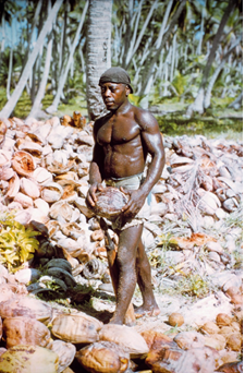 A Chagossian and his final coconut harvest, photographed at the time of the first United States encampment (1971). Source: Wikipedia |